Khagrachhari District · Chattogram Division · আলুটিলা গুহা
Alutila Cave travel guide
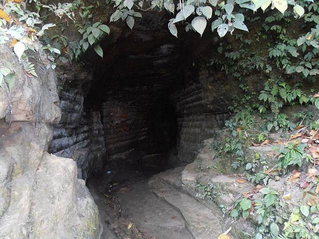
A dark, mysterious cave through the hill; you cross it with a flaming torch.
At a glance
- Length
- About 350 ft
- Location
- Matiranga, 7 km from Khagrachhari town
- Height (hill)
- Said to be about 3,000 ft above sea level
- Entry
- Small ticket; torch hire
History and details
The Alutila tourist spot beside the Khagrachhari–Chattogram road is run by the district administration. The story of the hill's name — during a famine in British times local people survived by eating wild potatoes from this hill, so it was called Alutila (potato hill).
The main attraction is the natural tunnel through the hill, called 'Matai Hakor', the cave of the gods, in the local language. It's completely dark inside, with cold stream water flowing underfoot; with a torch you can get from one end to the other in about 10–15 minutes.
From the viewpoint on top you can see Khagrachhari town and the surrounding hills; almost everyone stops here on the way to or from Sajek.
Things to do
- Cross the cave with a flaming torch
- See Khagrachhari town from the viewpoint
- Visit Richhang Waterfall the same day
How to get to Alutila Cave
About 7 km from Khagrachhari town; by CNG.
Khagrachhari is about 270 km from Dhaka; the journey takes 6–7 hours.
- 🚌 By bus: Shanti, Shyamoli, Hanif, Saint Martin from Sayedabad/Kalabagan; non-AC ৳700–850, AC ৳1,300–1,700.
Where to stay
- Parjatan Motel Khagrachhari
- Mid-range hotels in town (৳1,200–3,000)
What to eat
Hill cooking (System restaurant is famous), bamboo chicken
Good to know
- Be sure to take a torch
- Slippery rocks inside — wear good sandals
- Khagrachhari town can be seen from the Alutila viewpoint
🚨 Emergency numbers
- 01320-159547Tourist Police, KhagrachhariDuty officer for this area
- 999National emergency servicePolice, fire service and ambulance; 24 hours, free
- 01320-222222Tourist Police control roomFor tourists anywhere in the country, 24 hours
- 01887-878787Tourist Police hotline
- 102Fire Service hotlineFire, accidents and rescue
🏥 Find the nearest hospital on the map ↗
Numbers are from the Bangladesh Police and Fire Service websites, last checked 11 October 2026.
More to see nearby
- Richhang Waterfall (4 km)
- Hanging bridge and Horticulture Park (6 km)
- Debota Pukur (15 km)
More places to visit in Khagrachhari district
- Richhang Waterfall — Water slides down a sloping rock face, like a natural slide.
- Debota Pukur (Matai Pukhiri) — A mysterious pond on a hilltop about 700 ft high.
- Horticulture Park and hanging bridge — A landscaped park with a lake and hanging bridge near town.
Read more on the blog
- Khagrachhari Travel Guide and Cost 2026: Tourist Spots, a 1-Day Plan and How to Get There — Khagrachhari is more than the road to Sajek. A torch-lit walk through Alutila Cave, the rock slide of Richhang…
- Sajek 2-Day Tour Plan and Cost 2026: From Dhaka, Chattogram or by Train — How to see Sajek and the best of Khagrachhari in two days, what it costs per person in a group of 4, 8 or 12, how to…
- Sajek Valley Travel Guide 2026: Cost, How to Get There and Where to Stay — Going to Sajek to watch the sunrise above the clouds? How to get there from Dhaka, chander gari fares, army escort…